

For July 14th’s update, CLICK ME
Afternoon text edit/update: Darby becomes the 3rd hurricane of the season for the East Pacific, while Celia continues to weaken according to the National Hurricane Center BOTH moving further AWAY from Mexico and out to sea. Sadly, yes, I have to keep saying that as every time a storm pops up FB Messenger, emails and texts come in with people worried over nothing. I will literally, put up the Bat Man signal in the sky image should a storm ever be a threat to our region.
Darby, is a weak Cat 1 hurricane wind max sustained winds of 75mph (it became a hurricane once it reached max sustained winds of 74mph) and Darby is 570 miles away from Cabo (Los Cabos) traveling west (opposite direction of Mexico) at 12mph and it expected to strengthen.
Celia has max sustained winds of 50mph as opposed to 65mph it has this morning. Celia will quickly become a remnant low (just a memory) in the next few days as it inches closer to the Islands of Hawaii.
end edit 3pm Cabo Time
No storms are coming to Cabo. This is just an update on these systems … 😊
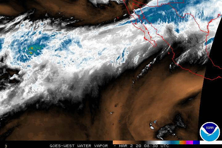
Small edit … forgot to add the daily GIF! This one, is of the water vapor. Notice how everything is moving AWAY from Mexico and out to sea? It’s all good here! The one on the left is Celia, the one southwest (one the right) is Darby. The clouds passing over BCS are just that, clouds, coming off of mainland that many are hoping bring us rain.
http://www.ssd.noaa.gov/goes/west/epac/wv-animated.gif
Tropical Storm Celia just might possibly bring some rain to Hawaii as a Tropical Depression if the system doesn’t completely tire itself out first. Didn’t I mention Hawaii last week? I do not have a crystal ball, it was just an educated guess and I do not keep track of how much rain Hawaii gets …


CLICK HERE for Direct Link to text below
000
WTPZ34 KNHC 131434
TCPEP4

BULLETIN
TROPICAL STORM CELIA ADVISORY NUMBER  28
NWS NATIONAL HURRICANE CENTER MIAMI FL       EP042016
800 AM PDT WED JUL 13 2016

...CELIA GRADUALLY FADING DUE TO COLD WATERS...


SUMMARY OF 800 AM PDT...1500 UTC...INFORMATION
----------------------------------------------
LOCATION...19.1N 132.6W
ABOUT 1485 MI...2390 KM W OF THE SOUTHERN TIP OF BAJA CALIFORNIA
MAXIMUM SUSTAINED WINDS...65 MPH...100 KM/H
PRESENT MOVEMENT...NW OR 305 DEGREES AT 12 MPH...19 KM/H
MINIMUM CENTRAL PRESSURE...990 MB...29.24 INCHES


WATCHES AND WARNINGS
--------------------
There are no coastal watches or warnings in effect.


DISCUSSION AND 48-HOUR OUTLOOK
------------------------------
At 800 AM PDT (1500 UTC), the center of Tropical Storm Celia was
located near latitude 19.1 North, longitude 132.6 West. Celia is
moving toward the northwest near 12 mph (19 km/h). A turn to the
west-northwest with no change in forward speed should begin later
today.

Maximum sustained winds have decreased to near 65 mph (100 km/h)
with higher gusts.  Additional weakening is forecast, and Celia
is expected to become a tropical depression in the next 48
hours or sooner.

Tropical-storm-force winds extend outward up to 140 miles (220 km)
from the center.

The estimated minimum central pressure is 990 mb (29.24 inches).


HAZARDS AFFECTING LAND
----------------------
None.


NEXT ADVISORY
-------------
Next complete advisory at 200 PM PDT.

$$
Forecaster Avila

Tropical Storm Darby


CLICK HERE for Direct Link to text below
000
WTPZ35 KNHC 131432
TCPEP5

BULLETIN
TROPICAL STORM DARBY ADVISORY NUMBER   8
NWS NATIONAL HURRICANE CENTER MIAMI FL       EP052016
900 AM MDT WED JUL 13 2016

...DARBY ALMOST A HURRICANE...


SUMMARY OF 900 AM MDT...1500 UTC...INFORMATION
----------------------------------------------
LOCATION...15.2N 112.4W
ABOUT 555 MI...895 KM SSW OF THE SOUTHERN TIP OF BAJA CALIFORNIA
MAXIMUM SUSTAINED WINDS...70 MPH...110 KM/H
PRESENT MOVEMENT...W OR 265 DEGREES AT 10 MPH...17 KM/H
MINIMUM CENTRAL PRESSURE...996 MB...29.42 INCHES


WATCHES AND WARNINGS
--------------------
There are no coastal watches or warnings in effect.


DISCUSSION AND 48-HOUR OUTLOOK
------------------------------
At 900 AM MDT (1500 UTC), the center of Tropical Storm Darby was
located near latitude 15.2 North, longitude 112.4 West.  Darby is
moving toward the west near 10 mph (17 km/h), and this general
motion is expected to continue for the next few days.

Maximum sustained winds are near 70 mph (110 km/h) with higher
gusts.  Strengthening is forecast during the next 48 hours, and
Darby is expected to become a hurricane later today.

Tropical-storm-force winds extend outward up to 80 miles (130 km)
from the center.

The estimated minimum central pressure is 996 mb (29.42 inches).


HAZARDS AFFECTING LAND
----------------------
None.


NEXT ADVISORY
-------------
Next complete advisory at 300 PM MDT.

$$
Forecaster Berg

And then there is that other area of low pressure that will have forecast tracks in the next few days …


CLICK HERE for Direct Link to Text Below
ZCZC MIATWOEP ALL
TTAA00 KNHC DDHHMM

TROPICAL WEATHER OUTLOOK
NWS NATIONAL HURRICANE CENTER MIAMI FL
500 AM PDT WED JUL 13 2016

For the eastern North Pacific...east of 140 degrees west longitude:

The National Hurricane Center is issuing advisories on recently
downgraded Tropical Storm Celia, located more than 1400 miles west
of the southern tip of the Baja California peninsula, and on
Tropical Storm Darby, located about 500 miles south-southwest of the
southern tip of the Baja California peninsula.

1. Disorganized shower and thunderstorm activity to the south and
southwest of the Gulf of Tehuantepec is associated with a tropical
wave.  An area of low pressure is expected to form in a couple of
days, and environmental conditions appear conducive for the low to
become a tropical depression over the weekend while it moves
westward to west-northwestward at 10 to 15 mph.
* Formation chance through 48 hours...low...10 percent
* Formation chance through 5 days...high...80 percent

Forecaster Berg

No long term forecast models today. We’ve got nothing coming our way here in Cabo.
~Jenn
OH! Music … internet radio is really our thing. The weather is just a hobby. We bring the sounds of Cabo San Lucas to the World, One Internet Connection at a time. http://www.livecaboradio.com/
Please give us LIKE on our FB page: https://www.facebook.com/LiveCaboRadio/
And … do not forget the hurricane FB group where we talk about when S*** gets real, what to do, what not to do, and keep each other updated. In the files section there are a few good but still being perfected lists of things everyone should have on hand in the event of ANY emergency: Hurricanes, Earthquakes, Financial Hardship … if we’ve got any preppers following us, we’d love more advice! https://www.facebook.com/groups/727074667339978/
Some on cells phones may have difficulty getting to the files section which is here. https://www.facebook.com/groups/727074667339978/files/
One comment